
Annonse
Mysterious remains of a huge, 'ship-shaped' house discovered near the Viking ship grave at Gjellestad
Archaeologists suggest that the almost 40-metre-long building may have been a house for ancient rituals, or a feasting hall.
Published
When archaeologist first examined Gjellestad in 2018, they were having a rather bad day at work, says Lars Gustavsen. He is an archaeologist at the Norwegian Institute for Cultural Heritage Research (NIKU).
The archaeologists were examining the site with a ground-penetrating radar, an instrument that uses radar pulses to map patterns and artifacts found under the ground. The georadar is mounted on a small tractor or an ATV.
“It was so wet that day, that we kept getting stuck, and repeatedly had to get help getting out”, Gustavsen says to sciencenorway.no.
But as the data they had collected was transferred to the computer, the world underneath them started to reveal itself. The images showed them a place that was probably very important in the ancient history of Norway.
“So all of a sudden it was a very good day at work”, Gustavsen says.
Annonse
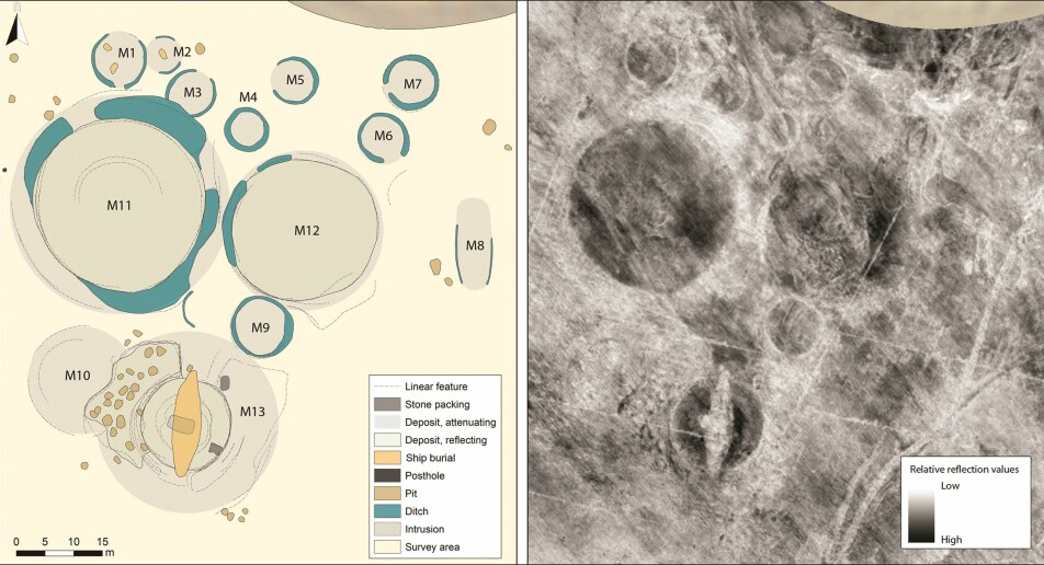
Burial mounds used to be lined up here
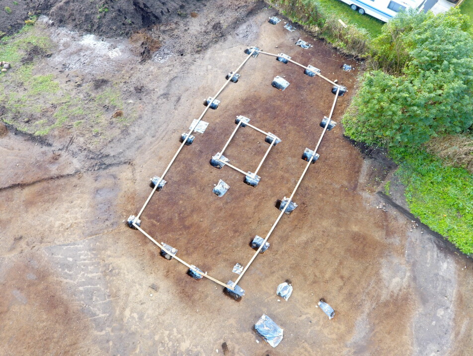
The most famous part of the Gjellestad-site, is the grave containing the Gjellestad Viking ship. This ship is currently under excavation, making it Norway’s first Viking Ship excavation in 100 years. The archaeologists who examined the findings found that it had to be excavated as soon as possible due to extremely unfavourable conditions.
But this ship grave was one of the last things that were built at Gjellestad, which is to be found near the city of Halden in South-Eastern Norway, on the eastern shores of the Oslofjord.
Currently, the only burial mound left is the large Jell Mound, but once upon a time burial mounds were lined up one after the other on this site. A site that may have played an important role in the surrounding society for several hundreds of years.
The mounds were leveled to the ground several decades ago, due to modern farming.
The meaning of the site at Gjellestad is now being discussed in a recent scientific article in the journal Antiquity. Sciencenorway.no has spoken to Lars Gustavsen, who led the work with the new study.
What was in that big building?
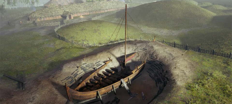
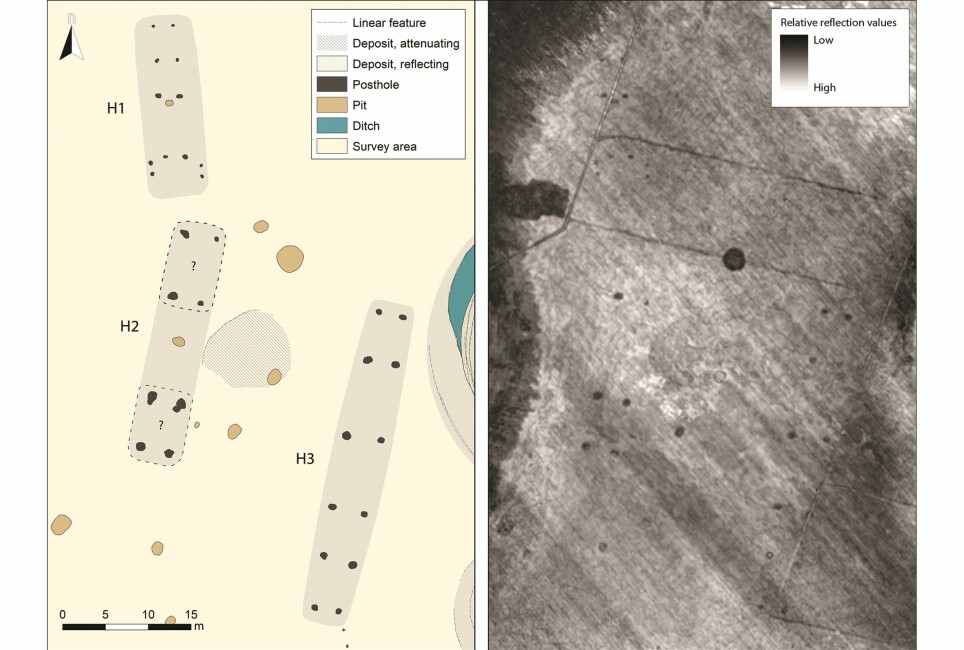
From the radar images, the archaeologists could see that four buildings were placed close to the burial mounds. You can see this yourself in the illustration at the top of this article.
This has not been excavated yet, so the researchers are left to interpret what the buildings may have been based on the images from the radar pulses.
Not much is left from the buildings, but you can se rows of holes. These are postholes. These holes were for solid posts that held up the entire roof of the building, Gustavsen explains.
One of these buildings, called H3, is being highlighted by the researchers as something special. It’s very large compared to other buildings found from this same period of time in this same area. The building is 38 metres long and seven metres wide. The placements of the postholes suggest that the building had outwardly curved walls, convex walls, sort of in the shape of a ship.
The postholes are so big that it is likely that this was a very tall and large building. The placement of the building would have made it visible in the landscape, so it could have had the function of a landmark.
Finally, there are no signs of this being a building where people lived. There are for instance no findings of a fire pit. In the article, the researchers argue that this could have been a cult house or a feasting hall.
“It could have been like a high seat of a chieftain, where perhaps everything from networking to religious rituals took place. There could have also been abundant drinking and brawls here.
Annonse
“The other buildings that surround this large one are also odd, which draws our interpretations toward a house of rituals”, says Gustavsen.
In the scientific article, the archaeologists argue that Gjellestad could have been a so-called high-status ‘central-place’ in the Late Nordic Iron Age (AD 550–1050) in this part of Norway. But what does that mean?
Wealthy people?
As the name suggests, this could have been an important place.
The typical features of such places are that there are burial mounds with rich findings, possible ritual buildings, and also trade and production of goods, says Gustavsen.
The researchers aren’t sure that trade and production took place nearby, but Gustavsen believes there are good chances it did.
“This is a place that expresses a position of power in the landscape”, he says.
“The family or the people who made these buildings, are maintaining their position of power by showing off with these buildings and these burials mounds”, says the archaeologist.
Several other features also suggest that this was a seat for the elite. In the Gjellestad mound, where the ship was buried, they have used turf collected from a different location – which suggests that great resources were used here.
You can read more about this in this article from The Norwegian Institute for Cultural Heritage Research: The Gjellestad burial mound belonged to the Iron Age elite.
But the timeline for this place is still not clear.
The ship grave was the last addition
Several clues suggest that the first burial mounds are from around 500 AD. This is called the age of migration in Norway, and is part of the Norwegian Iron Age.
But there are few good datings from this place. Archaeologists cannot date the place based on the images from the georadar. In order to date the place properly with a carbon dating, they need biological material which has not been contaminated, for instance coal from a fire pit.
The Viking ship has so far been dated to having been built some time between late in the 700s and early in the 900s, in other words early Viking age.
“We can with certainty say that this ship grave is one of the last things that happens on this site”, says Gustavsen.
He tells sciencenorway.no that this can be interpreted in different ways. Either this is a dominant family fortifying its position by placing a large and eye-catching ship grave on the site.
“Or it could be another family coming in and taking over. They are then demonstrating the take-over by placing their ship grave in an already existing site of power”, he says, adding that:
“We may never know which it is”.
If this area is to be excavated in the future, Gustavsen believes it would be useful to get good carbon dating from the different buildings and the burial mounds. Then we could find out if the buildings were built here at the same time, or if it was a place that developed over centuries.
“We also don’t know why this place was important. Did they perhaps have control over the sea lane, or control of the roads?”.
There are still many unanswered questions about Gjellestad.
Translated by: Ida Irene Bergstrøm
Reference:
Gustavsen et al: Gjellestad: a newly discovered ‘central place’ in south-east Norway. Antiquity, 2020. DOI: 10.15184/aqy.2020.39.
———


