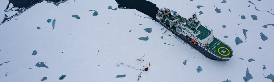
On 9 February, R/V Kronprins Haakon departs on a winter process cruise to the Barents Sea to track and measure important processes taking place in the ocean during wintertime. This cruise is led by UNIS professor Frank Nilsen and part of the Nansen Legacy project – Norway’s biggest research project to date.
Frank NilsenFrankNilsenUNIS Professor. Nansen Legacy Winter Process Cruise leader
Published
Arctic seas have historically been little accessible during winter, but it is during this time of the year that important atmosphere-ocean-processes are taking place. The heat fluxes between the sea and the atmosphere are greatest during winter. These processes are crucial for the Barents Sea for the rest of the year and affects, among others, how much of the ocean is covered by ice, what body of water is dominant, and how much nutrients are available for plankton before sunlight returns.
Nansen Legacy scientists are eager to start a new field season after a year with home office, lock-down and Covid-19. After months of scientific preparations, risk analysis and home quarantine, 16 researchers from University of Bergen, Norwegian Polar Institute, NTNU, Meteorological Institute of Norway and UNIS are ready for departure on the first winter process cruise leaving Longyearbyen on 9 February and arriving in Tromsø on 1 March.
Air-sea-ice interactions
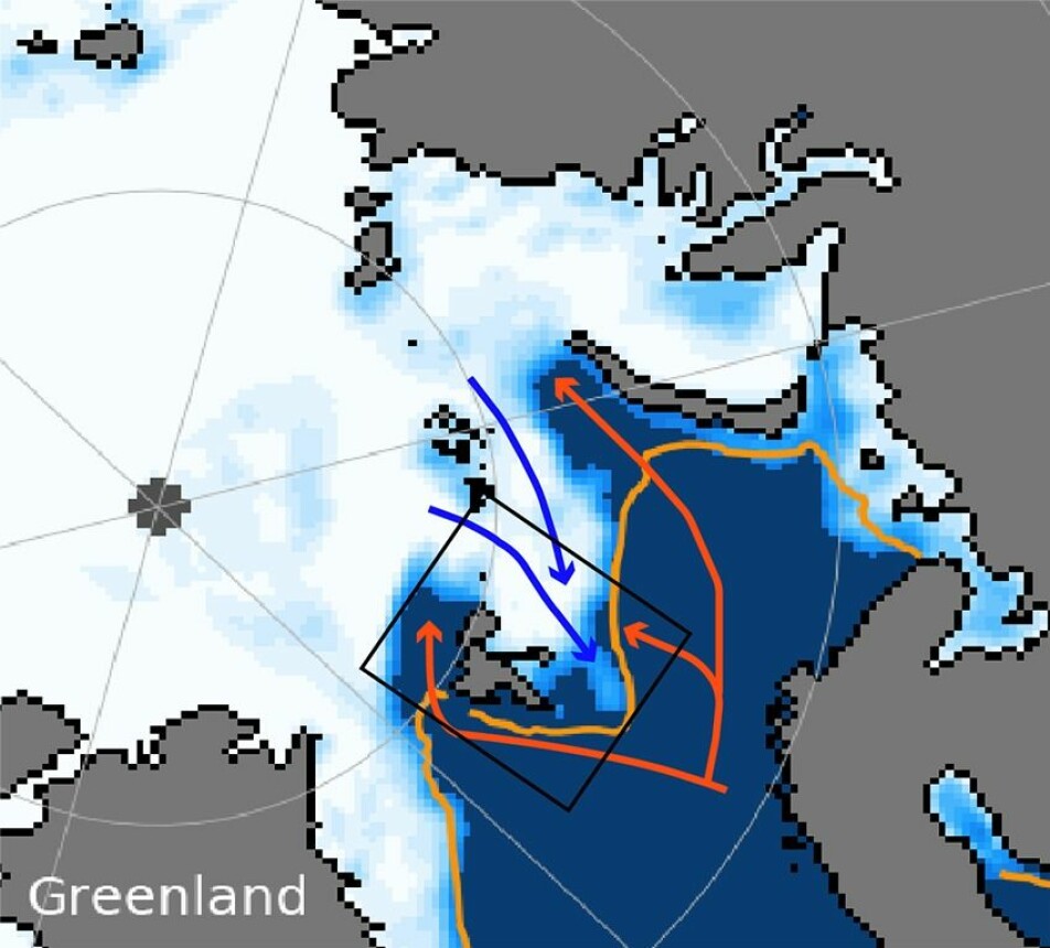
At this time of year, important inflows of warm water masses from the Atlantic Ocean take place in the north-western Barents Sea, and the vertical mixing throughout the water column is most effective. Historically these sea areas have been inaccessible (Figures 1 and 2) during winter, but thanks to the research icebreaker R/V Kronprins Haakon, these ice-covered parts of the Barents Sea are now possible to explore. This cruise focuses on the physical processes in the sea, the sea ice, and the atmosphere, as well as the interactions between them. Important tasks during the expedition will be to study the processes that determine the position and variability of the Polar Front between warmer and colder water masses in the northern Barents Sea as well as the distribution of different water masses. In addition, the cruise will investigate vertical turbulent mixing processes, and collect data from oceanographic moorings., Further, the cruise will be used to develop advanced robot technology and self-propelled crafts in both ocean and atmosphere.
It is during the winter months that the sea ice settles in the Arctic and in the Barents Sea, and it grows in distribution and thickness until mid-March when the maximum ice distribution is reached. How large the ice extent ends up and how thick the ice becomes, is determined by the processes that take place in the ocean from December to March. Every winter we experience winter storms that hit Norway on their way north towards the Barents Sea and Svalbard. How the sea and the warm ocean currents respond to the strong winds depends on where in the Barents Sea the low-pressure fronts hit. It is during this time of the year the impact of the atmosphere on the sea is greatest, through strong winds and large heat loss to the atmosphere, which is many degrees colder than the sea. The heat loss to the atmosphere cools the water masses and makes it ready to freeze sea ice, whilst the strong winds create stronger ocean currents and a greater heat transport into the Barents Sea that melts the sea ice. Which of these processes wins the battle can be decided during our cruise period.
Annonse
Studying the Polar Front
The north-western part of the Barents Sea is more or less the last part of the Barents Sea with solid sea ice in winter (Figure 1). Under the sea ice we find the cold and fresher Arctic water masses that make it possible for the sea ice to exist in the area. However, the sea ice cover and the Arctic waters masses are attacked by warm and salty Atlantic waters from both the South and the North. Most of the warm water enters the Barents Sea from the South, flowing further north- and eastwards, melting sea ice on its way. We define the area where the Atlantic water meets the Arctic water as the Polar Front. It is here we will take most of the measurements and study the movements and changes of the Polar Front. Advanced research “torpedoes” armed with oceanographic instruments will try to find the Polar Front on their own, and then follow it based on their own measurements and choices. In addition, we are launching an advanced sea glider that will observe the mixing processes in the upper 150 meters around the Polar Front area throughout the cruise.
Figure 1: Sea ice concentration (white) for 5 February 2021 taken from the National Snow and Ice Data Center (nsidc.org). The orange line marks the sea ice front over the years from 1981-2010. The red arrows indicate where the warm Atlantic Ocean water flows and the blue arrows indicate where Arctic water flows into the Barents Sea. The black box shows the cruise and the Nansen Legacy project’s study area.
Under, in and over the sea ice
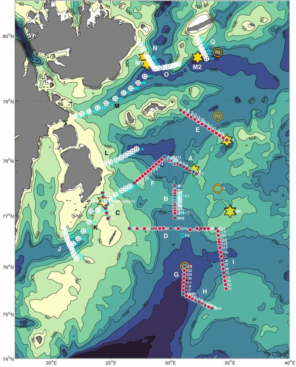
Beside the Polar Front, we will also study Kvitøyarenna, a deep trench between Nordaustlandet and Kvitøya, through which warm Atlantic water penetrates into the Barents Sea. We will go far into the ice in this area to conduct measurements (Figure 2). The warm water that we will encounter here has flown along the entire west coast of Spitsbergen and reached north of Svalbard, and again it is low pressure and strong winds that determine whether the Atlantic water enters the Barents Sea from the North. The Nansen Legacy has oceanographic moorings that measure temperature, salt, current velocity, as well as many chemical and biological parameters in all areas where warm water can penetrate into the north-western Barents Sea. In Kvitøyarenna, old data will be retrieved, and new instruments will be released. To better understand the impact of warm water on sea ice, and thus also improve current sea and sea ice models, observations will be collected over several days under the ice, in the sea ice and over the ice. In addition, drifters (GPS transmitters) that monitor the ice movement, and sensors that measure wave attenuation inwards in the ice masses, will be set out in strategic positions.
Figure 2: Observation area to be covered in the north-western Barents Sea during the winter process cruise. Different measuring stations are marked on the map.
With the assistance of researchers from several disciplines in physics, and with state-of-the-art instruments that measure the sea, the atmosphere and in the sea ice, we will try to reveal the secrets of the sea in the winter darkness. We are missing this data from our databases, and data collected at this time of year are unique. They will form a good basis for a better understanding of the Barents Sea ecosystem and the changes it undergoes.
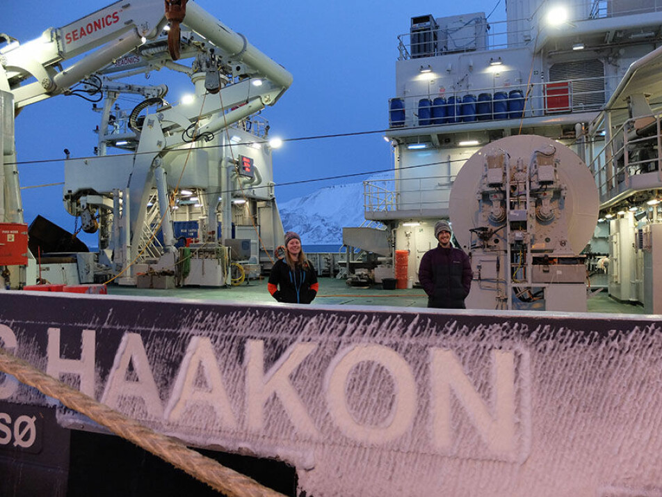
UNIS PhD candidate Kjersti Kalhagen and Nansen Legacy data manager Luke Marsden on board R/V Kronprins Haakon, ready to set sail from Longyearbyen in a few hours.(Photo: Maria Rossi/UNIS)
This blog is written by researchers and participants linked to The Nansen Legacy Project. They will share their experiences and knowledge from research cruises in the Barents Sea. The research vessel F/F «Kronprins Haakon» gives unique opportunities to explore the rapidly changing climate and ecosystems in the Arctic. To ensure a sustainable management of the Northern Barents Sea and the adjacent Arctic Basin throughout the 21st century a new knowledge base is required.