
Annonse
Share your science:
65 536 shades of grey can help us understand our geological past
SHARE YOUR SCIENCE: When medicine met geology - detecting the invisible traces of volcanic eruptions with CT scans.

Published
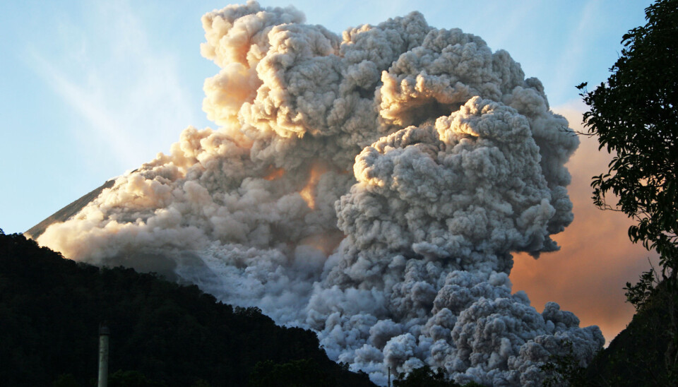
The unique geochemical fingerprint of volcanic ash can help us identify past eruptions. Earth scientists were quick to realize the possibilities of this approach to determine the age of geological deposits like a succession of sediment or rock layers. Today, a whole research field is dedicated to this effort. And a very dynamic one: most studies focused on visible layers just decades ago, while a new generation of researchers now trace invisible layers across continents.
However, the pace of discovery is held back by the laborious laboratory steps needed to separate ash from geological materials. In a new study published in Frontiers in Earth Science, we try to save valuable time with a technique that is unfamiliar to most geologists but essential in modern medicine: Computed Tomography or CT. Our work shows that invisible layers of ash that are thinner than the width of a human hair can be detected on scans. And these exciting results were achieved with software that can be used by anyone who`s interested.
Dating problems
Geological questions often deal with time. Take the study of past climate change: to better understand how our planet may respond to global warming, researchers want to target specific periods that were warmer than today. Thankfully, there are a number of dating methods to help geologists figure out how old their material is. The most popular of them all relies on the radioactive decay of carbon. This so-called radiocarbon dating method can determine the age of samples from the past 50 000 years: a period that is of great interest as it saw humans emerge and develop in an environment that was broadly similar to today`s world. Radiocarbon dating does, however, require enough organic material that is rich in dateable carbon. This is often problematic in desolate areas like the polar regions or deep oceans. To overcome these dating problems, researchers have developed other approaches that do not depend on organic material or radioactive decay. One of these is tephrostratigraphy: the dating of volcanic ash layers.
This technique builds on two important assumptions: volcanic ash has a distinct geochemical composition and is deposited in a geological instant. Because of this, each layer represents a unique time marker. And once identified, new finds of known ash layers provide researchers with valuable dating points. As an added bonus, widely scattered layers can be used to align different geological deposits found within that dispersal area. Such efforts are important to better understand how climate conditions varied from place to place. Because of this potential to date and match geological deposits, tephrostratigraphy has become a popular method.
Annonse
Progress is, however, somewhat held back by the repetitive and time-consuming laboratory steps that are required to separate volcanic ash. These steps primarily harness the subtle density difference between ash and its host material. By suspending samples in heavy liquids, light materials like plant remains float and heavy particles like sand grains sink until we are left with pure ash. When sampling every centimetre of metres-long geological deposits like sediment cores from the bottom of the ocean, this takes a lot of time.
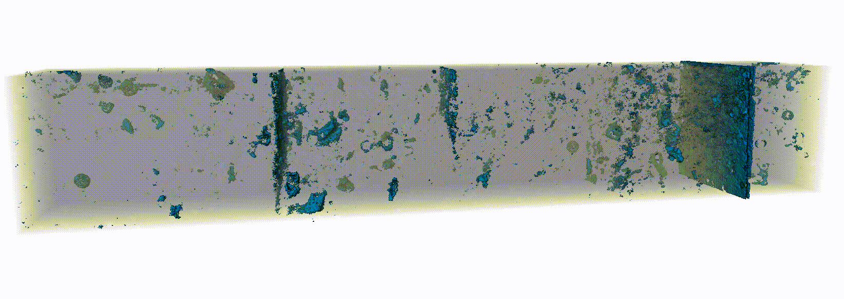
CT scan reveals invisible volcanic ash (in blue) (Illustration: van der Bilt et.al.)
65 536 shades of grey
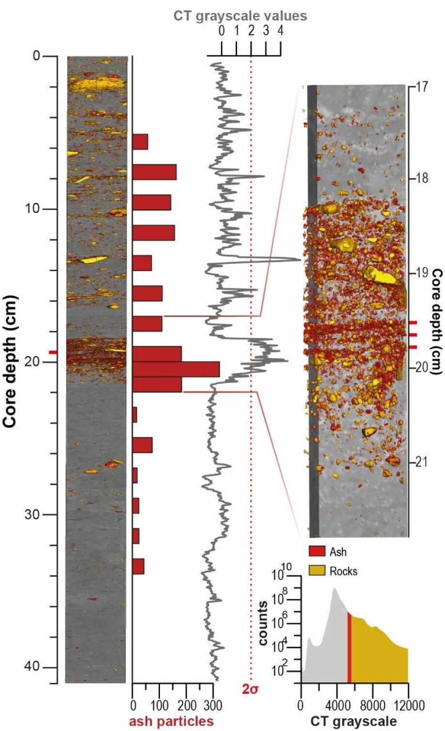
So, wouldn`t it be possible to find a quicker way to separate volcanic ash from geological records? We think there is, and it involves a cornerstone of medicine: Computed Tomography (CT). This method essentially visualizes objects based on their density: the same material property used to separate volcanic ash. Dense objects appear white, while lighter materials look dark. As anyone who ever broke a bone can tell, this principle highlights fractures on CT radiographs. In between the extremes of this black-white range, density differences are reflected by shades of grey. 65 536 in fact, when using a 16-bit CT scanner. Would this be enough to resolve the subtle differences between volcanic ash and its host material?
To find out, we designed an ambitious laboratory experiment where invisible ash layers were added to often-analysed geological materials like ice, mud and peat. We then checked whether CT scans could visualize these microscopic deposits. Adding to the challenge, we set out to do so by only relying on image processing steps that can be learned by most researchers. Somewhat to our surprise, this approach paid off as we detected all invisible layers.
Encouraged by these findings, we then applied the same successful processing steps on real geological records: sediments cores where researchers had already identified and published volcanic ash layers using traditional methods. Luckily for us, we have access to a CT scanner that is customized for the analysis of such cores. As can be seen in the below figure from our study, scans identify the same picks detected through laboratory work and even distinguish closely spaced horizons that are so thin that they were not detected before.
We hope that our promising results will encourage other tephra researchers to use CT scanning data to quickly locate volcanic ash layers of interest. In addition, our approach also open doors for other geological CT applications, for example automatic identification of traces left behind by past extreme events like floods or storms. We certainly expect CT scanning will continue to advance geoscience and look forward to playing a role in this exciting journey of discovery.
Reference:
van der Bilt W.G.M., Cederstrøm J.M., Støren E.W.N., Berben S.M.P., Rutledal S. Rapid Tephra Identification in Geological Archives with Computed Tomography: Experimental Results and Natural Applications. Frontiers in Earth Science 8, (2021)
Share your science or have an opinion in the Researchers' zone
The ScienceNorway Researchers' zone consists of opinions, blogs and popular science pieces written by researchers and scientists from or based in Norway.
Want to contribute? Send us an email!


